

")
Navigation, ein interessantes Thema, das vielen unterschiedlichen Philosophien folgt. Von immer der Nase nach, mit der Papierkarte auf dem Tank, ob mit dem Roadbook vor der Nase, oder aber via Handynavigation über diverse Apps, alle Varianten haben ihre Berechtigung und werden genutzt. Dabei ist es auch egal, ob man Onroad oder Offroad unterwegs ist, denn das Kartenmaterial ist in allen Bereichen mittlerweile umfassend und die Zeiten der Erstentdeckungen lange vorbei. Auch ich habe den größten Teil der oben genannten Varianten bereits durch und bin nach 12 Jahren Garmin Zumo 660 letztes Jahr beim Garmin Zumo XT gelandet.


Das neue Topmodel von Garmin soll sowohl Fahrer von Reiseenduros glücklich machen, aber eben auch alle anderen die auf Connectivity und einfache Bedienbarkeit stehen. Anbei meine Testeindrücke und Erfahrungen mit dem neuen Garmin Zumo XT on the Road.
Der Zumo XT
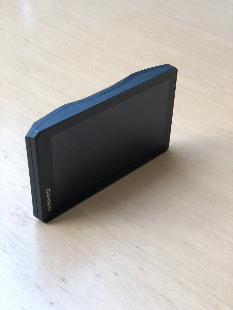
Schon beim Auspacken des neuen Gerätes fällt das klare Design ins Auge. Ein Design das aber zugleich Fragen aufwirft! War beim 660 das Display noch deutlich mit einem schützenden Kunststoffwulst umgeben, hat der XT hier gar nichts. Es empfiehlt sich also auf jeden Fall eine schützende Panzerglas Folie auf dem Display zu installieren, um Bruchschäden bei einem Sturz zu vermeiden. Gerade auch weil Garmin mit dem XT gezielt auf die Gruppe der Reiseenduristen zugeht. Das Navi kombiniert nämlich die Vorteile der Straßennavigation (Routing auf Straßenkarten), mit dem Routing auf Basis von topographischen Karten wie bei Offroad-Navis üblich.
WiFi-Installation problemlos
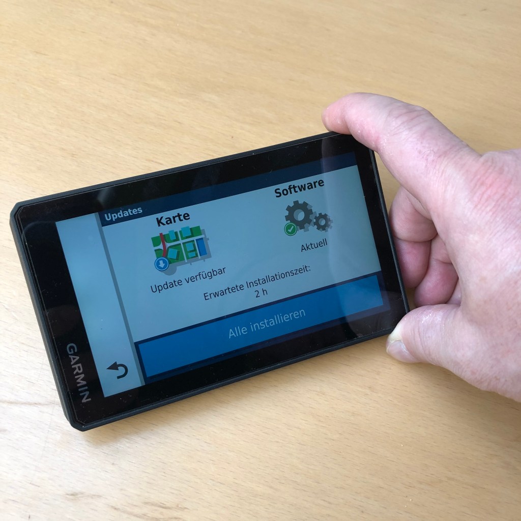
Vor dem ersten Einsatz ist allerdings die Installation der Software der nächste Punkt auf der to do Liste. Hier tauchen verschiedene Garmin spezifische Schlagwörter wie Garmin Connect, Garmin BaseCamp, Garmin Explore, Garmin Drive, Garmin Express auf mit denen man sich erst einmal kurz beschäftigen sollte. Von den genannten war mir aus der Zeit vor dem XT nur BaseCamp bekannt. Die nutzerunfreundliche Bedienbarkeit dieses veralteten Systems führten schon früher dazu, dass ich es mied wie der Teufel das Weihwasser und das ist auch heute noch so. Die Installation über WiFi indes verlief im Test vollkommen problemlos und auch die immer wieder folgenden Updates zieht sich das Gerät bisher ohne Murren und Meckern. So auf Stand gebracht kann der XT einiges leisten. Was genau lest ihr hier….


Garmin Zumo XT – Die Features
- Besonders helles und 5,5 Zoll großes Display. Bei Tag, Nacht und sogar Niederschlag perfekt ablesbar.
- Automatische Routen erstellen: Mit Garmin Adventurous Routing™ findest man besonders kurvige und bergige Routen fernab von monotonen Straßen.
- Mehrere Kartenarten: Wechsle mühelos zwischen klassischen Straßenkarten, topografischen Karten und BirdsEye-Satellitenbildern.
- Wasserdicht und robust: Das äußerst robuste und wasserdichte Motorrad-Navi ist auch den harten Touren gewachsen. Selbst bei Regen kannst du das Touchdisplay mit Handschuhen mühelos bedienen.
- Akkulaufzeit: Bei einer Beleuchtungshelligkeit von 100% hält der Akku bis zu 3,5 Stunden. Maximal sind 6 Stunden möglich, wenn du die Standardeinstellung wählst. Alternativ kannst du das Gerät für längere Abenteuer an eine Konstantstromquelle anschließen.
- Live Wetter, Live Traffic und Mehr via Garmin Drive App
- TripAdvisor, Foursquare, iOverlander und Garmin Motorrad POIs
- Bluetooth-Freisprechfunktion, Musiksteuerung und integrierter MP3-Player
- Integrierter Track Recorder mit Kompass sowie Höhenprofil
- Mit Garmin Explore sowie inReach-Geräten (separat erhältlich) kompatibel
Garmin Zumo XT – Lieferumfang
- Garmin Zumo XT Navigationsgerät
- Motorradhalterung inkl. Adapterplatte
- Motorrad-Anschlusskabel für feste Installation am Fahrzeug
- Auto-Halterungsset mit Saugnapf und USB-Ladekabel auf USB-Mini
Garmin Zumo XT – Display und Darstellung
Nach all dem Einrichten und Montieren der Halterung am Bike verliefen die ersten Testtouren super. Die Verbindung mit dem Handy klappte sogar so gut, dass ich einige der Haken in der Software des Garmin deaktivieren musste, da die Schwemme an Infos mir während der Fahrt einfach viel zu groß war. Das Navi ist außerdem wie die 3er und 5er im Hochformat und Querformat montierbar. Dabei zeigt das Display mit (1280 x 720 Pixel) seine gesamte Performance und ist jederzeit sehr gut ablesbar. Vor allem die On/Off Roadfahrer werden ihre reine Freude am neuen Gerät haben, denn die Kombination von Topo-Karten, Straßenkarten und sogar Satellitenbildern macht wirklich Sinn und zudem hat man bei Bedarf durch die WiFi-Verbindung via Hotspot die Möglichkeit auf BirdsEye Satellitenfotos zurück zu greifen.
Garmin Zumo XT – Bedienung
Die Navigationswelt einfacher machen mit dem XT gelingt das ganz ausgezeichnet. Ebenso auch die Bedienung mit den verschiedensten Handschuhtypen. Der Prozessor im Inneren ist flott und sämtliche Eingaben laufen flüssig ab. Zudem kann man das Beste aus zwei Welten nämlich Apple und Google über die Autosuggestion Funktion kombinieren. Bedeutet beim nächsten Stopp, Picknick oder Kaffee kann man den nächsten oder einen neuen Routenpunkt rasch via Google Maps ins Handy eintippen und über die App Garmin Drive über nimmt der Zumo die Daten für die Navigation. Natürlich muss hierfür die Garmin Drive APP auf dem Handy installiert sein.


Garmin Zumo XT – Routing mit Adventurous
Wer nicht wie ich seine Routen am Navi direkt oder über Kurviger.de plant, findet unter Umständen mit der Adventurous Routing Funktion eine tolle Funktion im Gerät. Hier sucht das Navi einfach eine schöne Motorradstrecke zum gewählten Ziel aus. Im Praxistext zu Hause wählte der Zumo einwandfrei die Motorradstrecken, die ich auch gewählt hätte. Bei der Preisgabe von zusätzlichen, oder gar Geheimtipps hielt es sich allerdings zurück. Für die Tour in unbekannten Regionen empfiehlt es sich also vorher noch einmal gegen zu checken, was man gerne sehen möchte denn sonst hat man ggf. nur eine wunderbare Tour zum nächsten Ziel.
Garmin Zumo XT – GPX Daten Austausch
Wer hin und wieder mit Freunden unterwegs ist und GPX Daten austauschen möchte kann dies nun z.B. sehr einfach via WhatsApp tun. Dabei wird die Datei aus WhatsApp einfach mit Hilfe der DriveApp ins Garmin Explore gespielt und von dort kann man sie wieder via DriveApp ins Navi holen. Damit spart man sich den Umweg über das benutzerunfreundliche Garmin BaseCamp. Zu Hause klappt diese Variante sehr gut, ebenso wie das Verschieben der Datei aus Kurviger.de direkt ins Gerät.
Garmin Zumo XT – Motorradhalterung
Wer den Zumo 660 gewohnt war und seine stabile und umfassende Halterung wird nun beim XT doch etwas enttäuscht sein. Gerade für die Zielgruppe der Reiseenduristen hätte man in Sachen Befestigung mehr beim alten und robusten System abschauen sollen. Die Verbindung Navi-Kontakt- Halterung wenig Vertrauenserweckend, das Aufstecken ist teils fummelig, da man automatisch immer noch ein-zweimal nachdrückt, um sicher zu gehen das das Gerät auch eingerastet ist. Man muss sich außerdem selbst um eine passende RAM-Mount bzw. Montagemöglichkeit der Halterung kümmern. Für die Praxis mit Handschuhen empfiehlt es sich daher lieber einmal mehr nachdrücken, da man den Einrastpunkt nicht fühlt.


Garmin Zumo XT – Preis
Die Preise für das Garmin Zumo starten im Netz bei 440 Euro. Garmin selbst preist es auf seiner Homepage mit rund 500 Euro an. Damit ist das Garmin Zumo XT in Sachen Preis, aber auch Leistung an der Spitze der Nahrungskette der angebotenen Motorradnavis angesiedelt. Wer einen Technikfabel hat und Connectivity schätzt, wird damit mehr als zufrieden sein. Wer bei all den genannten Apps und Featuren ins Straucheln gerät und diese ohnehin nicht zu nutzen weiß, der sollte besser nach einem Zumo 660 Ausschau halten.
Fazit
In meiner Welt des Motorrad Fahrens ist nur wenig Platz für die althergebrachte Landkarte. Natürlich habe ich auf unseren Reisen immer eine für den Notfall im Gepäck mit dabei, allerdings gebraucht habe ich sie bisher nie. Von der Handynavigation via CalimotoAPP oder anderen Apps dieser Art sehe ich mittlerweile auch ab, da ein Handy, eben ein Handy ist und kein voll taugliches und vor allem wasserdichtes Motorradnavigationssystem. Außerdem liebe ich es meine Touren am PC zu planen und mit Kurviger.de auszuarbeiten. Das verlustfreie Überspielen auf den Garmin danach ist mittlerweile kein Problem mehr und ich habe alles beieinander. Daher und mit den zusätzlichen Gerätefunktionen (außer dem Sozialmediagedöhns welches man ausschalten kann) bin ich mit dem Zumo XT bestens aufgestellt und für die Tour gerüstet.
In diesem Sinne #Lifeisaride
Torsten Thimm
Garmin Zumo XT Navigation
Navigation is an interesting topic that follows many different philosophies. From always following the nose, with the paper map on the tank, whether with the road book in front of the nose, or via mobile phone navigation using various apps, all variants have their justification and are used. It doesn’t matter whether you’re travelling on-road or off-road, because the map material is now comprehensive in all areas and the days of first discoveries are long gone. I, too, have already gone through most of the above-mentioned variants and, after 12 years of using the Garmin Zumo 660, ended up with the Garmin Zumo XT last year.
The new top model from Garmin should make both riders of touring Enduros happy, but also everyone else who likes connectivity and ease of use. Here are my test impressions and experiences with the new Garmin Zumo XT on the road.
The Zumo XT
As soon as you unpack the new device, the clear design catches your eye. A design that at the same time raises questions! While the display of the 660 was clearly surrounded by a protective plastic bead, the XT has nothing at all. It is therefore advisable to install a protective armoured glass film on the display to prevent breakage in the event of a fall. Particularly because Garmin is targeting the travel Enduro group with the XT. The navigation device combines the advantages of road navigation (routing on road maps) with routing on the basis of topographical maps, as is usual with off-road navigation devices.
Wi-Fi installation without problems
Before the first use, however, the installation of the software is the next item on the to-do list. This is where various Garmin-specific keywords such as Garmin Connect, Garmin BaseCamp, Garmin Explore, Garmin Drive come up that you should first briefly familiarise yourself with. Of these, only BaseCamp was known to me from the time before the XT. The user-unfriendly usability of this outdated system led me to avoid it like the devil avoids holy water, and that is still the case today. The installation via Wi-Fi, however, went off without a hitch in the test, and the device has so far also been able to update itself without grumbling or complaining. Updated like this, the XT can do a lot. What exactly you can read here….
Garmin Zumo XT – The features
- Particularly bright and 5.5-inch display. Perfectly readable by day, night and even precipitation.
- Create routes automatically: With Garmin Adventurous Routing™ you can find especially curvy and mountainous routes far away from monotonous roads.
- Multiple map types: Easily switch between classic road maps, topographic maps and BirdsEye satellite imagery.
- Waterproof and robust: The extremely robust and waterproof motorbike navigator is also up to the toughest tours. Even in the rain, you can operate the touch display effortlessly with gloves on.
- Battery life: At 100% brightness, the battery lasts up to 3.5 hours. A maximum of 6 hours is possible when you select the standard setting. Alternatively, you can connect the device to a constant power source for longer adventures.
- Live Weather, Live Traffic and More via Garmin Drive App
- TripAdvisor, Foursquare, iOverlander and Garmin Motorcycle POIs
- Bluetooth hands-free calling, music control and integrated MP3 player
- Integrated track recorder with compass and altitude profile
- Compatible with Garmin Explore and inReach devices (sold separately)
Garmin Zumo XT – What’s included
- Garmin Zumo XT navigation device
- Motorbike mount incl. adapter plate
- Motorbike connection cable for fixed installation on the vehicle
- Car mount kit with suction cup and USB charging cable on USB mini
Garmin Zumo XT – Display and Presentation
After all the setup and mounting of the mount on the bike, the first test tours went great. The connection with the mobile phone worked so well that I had to deactivate some of the hooks in the Garmin software, as the flood of information was simply too much for me during the ride. For the first time, the navigation system can be mounted in portrait or landscape format. The display (1280 x 720 pixels) shows its full performance and is always extremely easy to read. On/off road riders in particular will be delighted with the new device because the combination of Topo maps, road maps and even satellite images really makes sense and, if necessary, you can also access BirdsEye satellite photos through the Wi-Fi connection via hotspot.
Garmin Zumo XT – Operation
Making the world of navigation easier with the XT is an excellent achievement. The same applies to operation with different types of gloves. The processor inside is fast and all inputs run smoothly. In addition, you can combine the best of two worlds, namely Apple and Google, via the autosuggestion function. This means that at the next stop, picnic, or coffee, you can quickly type the next or a new route point into the mobile phone via Google Maps and the Zumo takes the data for navigation via the Garmin Drive app. Of course, the Garmin Drive APP must be installed on the mobile phone.
Garmin Zumo XT – Routing with Adventurous
If you don’t plan your routes directly on the navigation device or via Kurviger.de like I do, you may find that the Adventurous routing function is a great feature in the device. Here, the navigation device simply selects a nice motorbike route to the selected destination. In practice at home, the Zumo flawlessly selected the motorbike routes that I would also have chosen. However, it was reluctant to reveal additional or even secret tips. When touring in unknown regions, it is advisable to check beforehand what you would like to see, otherwise you may only have a wonderful tour to the next destination.
Garmin Zumo XT – GPX Data Exchange
If you are on the road with friends from time to time and want to exchange GPX data, you can now do this very easily via WhatsApp, for example. The file from WhatsApp is simply transferred to Garmin Explore with the help of DriveApp and from there it can be transferred back to the navigation device via DriveApp. This saves you the diversions via the user-unfriendly Garmin BaseCamp. At home, this variant works very well, as does moving the file from Kurviger.de directly into the device.
Garmin Zumo XT – Motorcycle Mount
Those who were used to the Zumo 660 and its stable and comprehensive mount will now be somewhat disappointed with the XT. Especially for the target group of travellers, more should have been taken from the old and robust system in terms of mounting. The connection between the navi contact and the mount does not inspire confidence, and the attachment is sometimes fiddly, as you automatically have to press down once or twice to make sure that the device is locked in place. You also have to find a suitable RAM mount or mounting option for the holder yourself. For practical use with gloves, it is therefore better to press down once more, as you will not feel the engagement point.
Garmin Zumo XT – Price
Prices for the Garmin Zumo start at 440 euros on the net. Garmin itself prices it at around 500 euros on its homepage. This puts the Garmin Zumo XT at the top of the motorbike navigation food chain in terms of price and performance. Anyone with a flair for technology and who appreciates connectivity will be more than satisfied. If you’re not sure how to use all these apps and features, you’d be better off looking for a Zumo 660.
Conclusion
In my world of motorcycling, there is little room for the old-fashioned map. Of course, I always carry one in my luggage for emergencies, but I have never needed it. I also refrain from using mobile phone navigation via CalimotoAPP or other apps of this kind, because a mobile phone is just a mobile phone and not a fully capable and, above all, waterproof motorbike navigation system. I also love planning my tours on the PC and working them out with Kurviger.de. The lossless transfer to the Garmin afterwards is no longer a problem and I have everything together. For this reason and with the additional device functions (except for the social media stuff that can be switched off), I am well equipped with the Zumo XT and ready for the tour.
In this sense #Lifeisaride
Torsten Thimm
