

Unsere Tour: https://kurv.gr/CXwv6
Auf der Passhöhe angekommen, zeigt sich meist die wahre Schönheit der Berge….

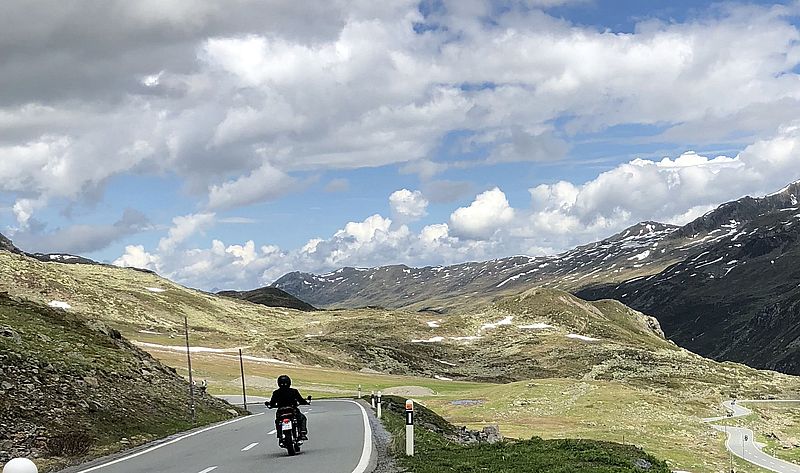
Der Flüela Pass
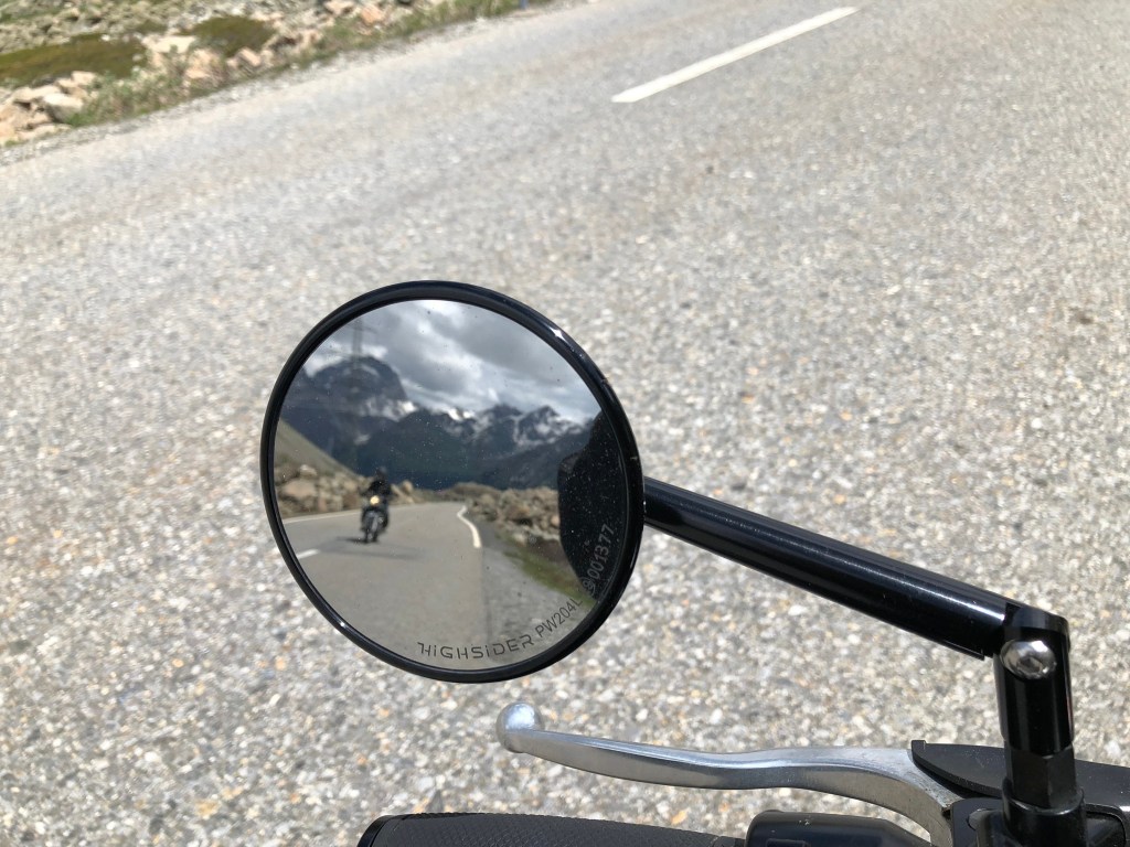
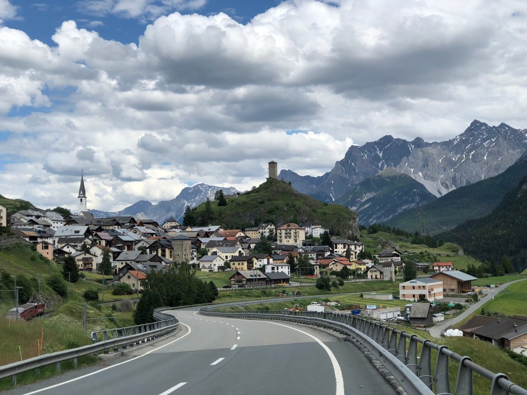
Carmen und ich haben Glück, denn die Straßen sind an diesem Junimorgen kaum befahren. Hier und da mal ein anderer Biker, der freundlich grüßt, ansonsten ringsum die geballte Bergwelt und der Sound unserer beiden Maschinen der von den Felswänden widerhallt. Ihr kennt das sicher auch, denn es ist einer dieser Tage an denen einfach alles passt und man hofft, dass er nicht so schnell vorübergeht. Gemütlich rollen wir durchs Unterengadin, ein Halt hier, ein weiterer Halt dort, vorbei an Scuol, Ardez und biegen in Susch auf die Flüela Passstraße ein. Eine Spitzkehre links, eine weitere rechtsherum und schon sind wir mitten im Kurvengetümmel des Passes. Nach dem Ortsschild von Susch nimmt der Verkehr kurzzeitig etwas zu, als im Rückspiegel eine flotte deutsche Motorradgruppe auftaucht. Ob sie wohl schon mal etwas von den Schweizer Strafen gehört haben? Egal, uns stört es nicht weiters, denn wir sind im Genussmodus zwischen Kurven und Natur gelandet und somit hier mit unseren Kawa‘s genau richtig unterwegs.


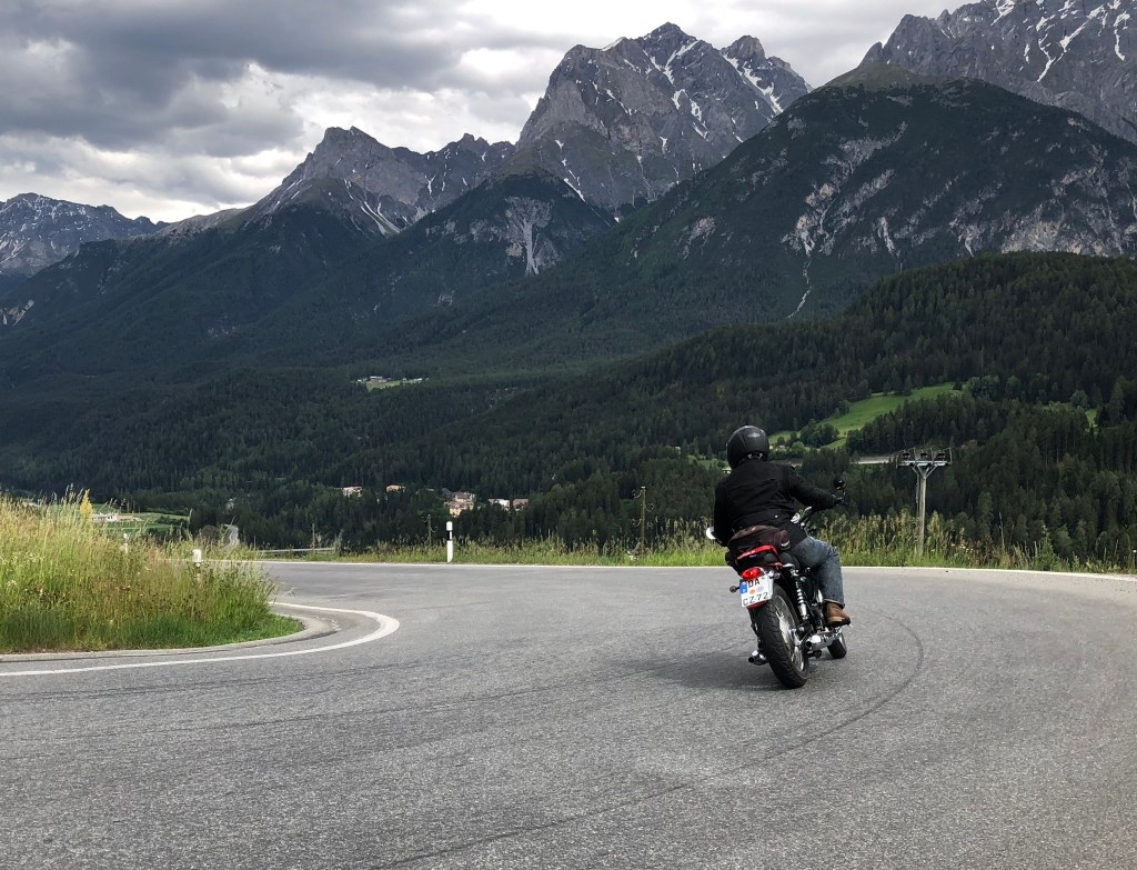
Kilometer für Kilometer geht es den Bergpass hinauf und wir gewinnen an Höhe. Dabei durchfahren wir die verschiedenen Vegetationszonen der Berge und genießen die mächtige Natur um uns herum und natürlich die gut ausgebaute Strecke zwischen Schwarzhorn und Flüela Wisshorn. Auf 2384 Metern erreicht der Pass seine Passhöhe und damit gleichzeitig die europäische Hauptwasserscheide. Ab hier beginnt der Abstieg Richtung Davos und ins Langwassertal. Umgeben von Almkühen und begleitet vom Klang ihrer typischen Kuhglocken rollen wir eingerahmt von den umliegenden Zwei- und Dreitausendern ins Tal. Allmählich verschwinden die Kühe im und es wird wieder leiser um uns herum. Die Almwiesen gehen nach und nach in niedrig wachsenden Latschenbewuchs über und vor Davos in den typisch alpinen Nadelwald.


Bei mittlerweile strahlendem Sonnenschein treffen wir vor Davos Dorf beim vorbeifahren die deutsche Motorradgruppe wieder, die uns so flott überholt hatte. In diesem Moment taten sie uns fast ein wenig leid, denn glücklich sahen sie in diesem Moment nicht aus. Die Schweizer Polizisten schienen ihren Job ernst zu nehmen und kontrollierten gerade ihre Papiere. Für uns indes war der Flüela Pass das erste Erlebnis des Tages und wie wir beinahe schon geahnt hatten bei weitem nicht das Letzte.
Der Albula Pass

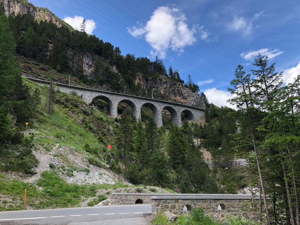
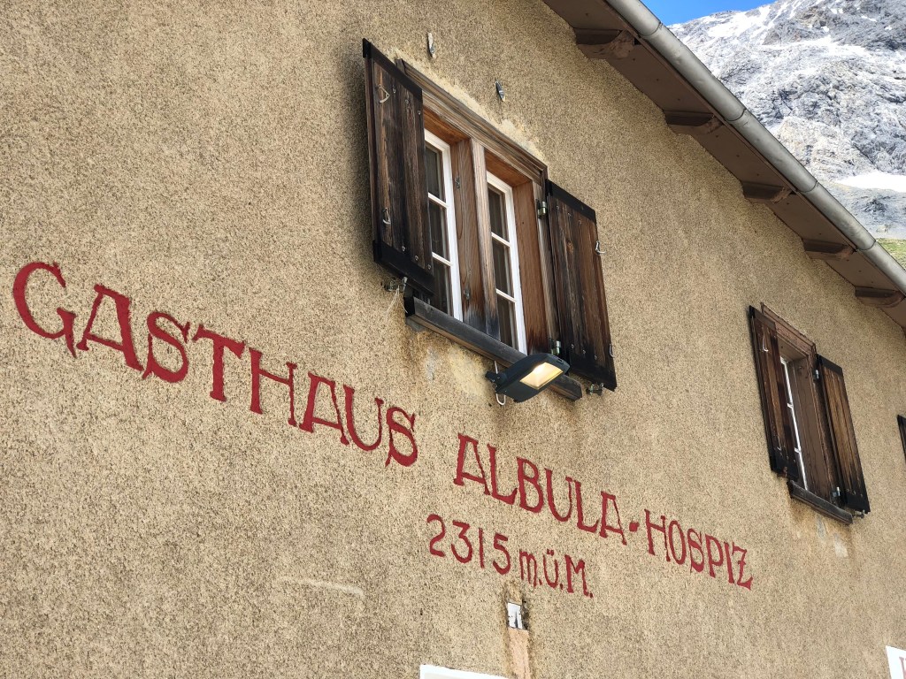
Den Davosersee rechts hinter uns lassend, durchqueren wir den Ort und folgen im Anschluss der 417 Richtung Wiesen und Schmitten, bevor wir in Alvaneu Dorf links abbiegen. Das Sträßchen, dem wir ab hier willig nachfahren, bringt uns zielsicher auf die Veja Alvra. Doch nicht ohne einen Blick auf die spektakuläre Kulisse, die sich uns bietet. Wie in einem der alten Heimatfilme grasen die Kühe vor uns auf den saftig grünen Wiesen. Im Hintergrund sieht man die Häuser und den Kirchturm des Dorfes umringt von den Bergen, deren weiße Spitzen in der Sonne glitzern. Hier lässt es sich gut leben, sagt Carmen durch das Intercom, während wir der Alvra parallel zum Albula-Bach und dem Albula-Bahnerlebnisweg folgen. Hinter Bergün wird die Straße ein wenig enger und vor allem auch wieder etwas kurviger. Einige Viadukte der Bahnlinie kreuzen perfekt in die Landschaft integriert die Straße, die von hier ab nach und nach in die Albula Passstraße übergeht. Auf 2315 Metern Höhe angekommen, parken wir die W’s und genießen im Albula Berghospiz ein köstliches Mittagessen und einen Cappuccino. Dabei genießen wir die wärmenden Sonnenstrahlen mit dem Blick hinunter ins Tal. Um uns herum ist es still, bis auf das eine oder andere Motorrad, das vorbeifährt, oder wie wir auf dem Parkplatz neben dem Hospiz anhält, um eine Pause einzulegen.


Unsere Pause geht indes langsam zu Ende. Noch ein wenig überrascht vom Rechnungsbetrag packen wir uns zusammen, starten die Motoren und folgen der hier oben erst einmal langgezogenen Geraden hinunter nach La Punt Chamues-CH. Von dort aus queren wir einige Male den Inn und landen schließlich auf der 28 die uns über den Pass Dal Fuorn ins Münstairtal führt. Normalerweise ist dieses Tal nach dem eher trägen und zumeist überfüllten Vinschgau das Erste in dem man vorm Umbrailpass etwas zur Ruhe kommen kann. Heute fahren wir es jedoch umgekehrt und haben den Vinschgau noch vor uns.


Die letzte Etappe
Erstaunlicherweise ist an diesem Nachmittag auf dem Weg zum Reschensee nichts los. Sichtlich überrascht über diese Situation passieren wir das Denkmal am Haide Park, halten kurz am Kirchturm im See an und setzen unsere Fahrt danach am linken Seeufer fort. Noch einmal haben wir hier zwischen den Bäumen den Kirchturm aus der nahen Ferne im Blick, bevor wir den See umrundet haben und hinunter ins Tal vorbei an der Festung Nauders zurück nach Landeck fahren. Damit endet dieser Motorradtag, aber natürlich nicht ohne die schönen Gedanken und Erinnerungen an die Schweizer Pässe und das Erlebte.


Geschichte und Infos
Flüela Pass
Man sagt das der 1867 fertig erstellte Flüela Pass die kürzeste Strecke zwischen dem Rheintal und dem Unterengadin bildet. Auch hier wie in anderen Gegenden der Alpen könnte es sein, dass es schon Verbindungen in der Steinzeit und zu Zeiten der Römer gab. Und natürlich sollte der Flüela wie die umliegenden Pässe während des zweiten Weltkrieges als Aufmarschgebiet und Sperrgebiet nutzbar gemacht werden. Dazu kam es glücklicherweise nie.
Der Flüela ist aufgrund seiner Lage nicht wintersicher und wird daher über diese Monate hin gesperrt. Zudem kann man von Davos aus in den Sommermonaten mit der Postkutsche bis zum Flüela Hospiz hochfahren und so die sensationelle Natur noch etwas mehr genießen. Dort oben endet unter anderem auch die Bündner Hauteroute die durch den Norden des Engadin verläuft und am Julierpass ihren Ursprung hat.
Albula Pass
Die Albula Bergstraße ist die erste Straße, die mit Sprengstoff aus dem Fels herausgearbeitet wurde. Das geschah bereits 1695, um die engen Teilstücke gangbarer zu machen. War sie zuvor lediglich eine Ausweichroute, so nahm der Verkehr ab diesem Zeitpunkt deutlich zu.
Ab 1904 konzentrierte man sich nach einer kurzen Wirtschaftsflaute in der Gegend dann verstärkt auf den Tourismus, der auch heute noch das Geschehen rund um den Albula Pass bestimmt. Ein Highlight ist dabei die rund 6 Kilometer lange Schlittelbahn zwischen Preda und Bergün auf der man ca. 20 Minuten und 400 Höhenmeter lang mit dem Schlitten unterwegs ist. Den Transport der Schlitten übernimmt überdies die Rhätische Bahn.
Das Essen und die Strafen in der Schweiz sind teils teurer als in den angrenzenden Ländern. Wir zahlen (ohne uns zu beschweren) am Hospiz für 2 Nudelgerichte, zwei Cola und zwei Cappuccino über 50 Euro. die Natur und vor allem der Ausblick entschädigte uns allerdings mächtig dafür. Übernachtet haben wir im österreichischen Teil des Dreiländerecks, allerdings findet man entlang der gefahrenen Strecke Unterkünfte in Hülle und Fülle für jeden Geldbeutel.
Fazit
Wie beim Furka Pass zuvor rentiert sich die Schweizer Berg- und Pässwelt immer für eine Reise. Hält man sich an die Geschwindigkeiten hat man nichts zu befürchten und hey wir sind ja im Urlaub und nicht auf der Flucht unterwegs. Die Landschaft gerade an den beiden genannten Pässen ist grandios und wer mehr möchte kann den Umbrail Pass und das Stilfser Joch mit in die tour einbauen. Und denkt daran wer Respekt haben möchte, der sollte auch bereit sein Respekt zu geben egal ob anderen Verkehrsteilnehmern gegenüber oder der Natur.
Und noch ein spezieller Tip wer das Moped mal stehen lassen möchte Mit dem Postauto durch die Schweiz

Beste Grüße Carmen und Torsten
Passepartout: Flüela and Albula Pass Coordinates: 46° 45′ 0″ N, 9° 56′ 50″ E and Coordinates: 46° 35′ 2″ N, 9° 50′ 20″ E
Our Tour: https://kurv.gr/CXwv6
Arriving at the top of the pass, the true beauty of the mountains is revealed….
The Flüela Pass
Carmen and I are lucky, because the roads are hardly busy on this June morning. Here and there another biker greets us in a friendly way, otherwise the mountain world and the sound of our two bikes echoing off the rock faces. You probably know this too, because it’s one of those sunny days where everything fits and you hope it won’t end so quickly. We roll leisurely through the Lower Engadine, a stop here, a stop there, past Scuol, Ardez and turn onto the Flüela pass road in Susch. One hairpin bend to the left, another to the right and we are already in the middle of the bustle of the pass. After Susch, the traffic picks up a little for a short while as a nippy German motorbike group appears in the rear-view mirror, probably not having heard about the Swiss penalties yet. No matter, we don’t mind, because we have ended up in enjoyment mode between curves and nature and are thus on the right track here with our Kawa’s.
Kilometre by kilometre, Carmen and I gain altitude, enjoying the mighty nature around us and the well-built route between Schwarzhorn and Flüela Wisshorn. At 2384 metres we reach the top of the pass and thus also the main European watershed. From here we begin the descent towards Davos and the Langwassertal valley. Surrounded by alpine cows and accompanied by the sound of their typical cowbells, we roll into the valley framed by the surrounding two- and three-thousand metre peaks. Gradually the cows disappear in the rearview mirror and it becomes quieter around us again. The alpine meadows gradually change into low-growing mountain pine growth and, before Davos, into the typical alpine coniferous forest.
In bright sunshine, we meet up again with the German motorbike group that had overtaken us so quickly in a car park before Davos village. They did not look happy at that moment, when the Swiss policemen checked their papers. For us, however, it was the first experience of the day and by no means the last.
The Albula Pass
Leaving Lake Davos behind us on the right, we cross the village and follow the 417 towards Wiesen and Schmitten before turning left in Alvaneu Dorf. The little road we follow from here on brings us unerringly to the Veja Alvra. But not without a glance at the spectacular scenery that presents itself to us. Like in an old home movie, the cows graze with their alpine bells on the lush green meadows. In the background you can see the houses and the church tower of the village surrounded by the mountains, their white peaks glistening in the sun. It’s a good place to live, Carmen says through the intercom, as we follow the Alvra parallel to the Albula stream and the Albula railway adventure trail. Behind Bergün, the road becomes a little narrower and, above all, more winding. Some viaducts of the railway line perfectly integrated into the landscape cross the road, which from here on slowly turns into the Albula pass road. Arriving at 2312 metres above sea level, we enjoy a delicious lunch and a cappuccino in the mountain hospice in bright sunshine and look down into the valley. All around us it is quiet, except for the odd motorbike passing by or, like us, stopping in the car park next to the hospice to take a break.
Our break, meanwhile, is slowly coming to an end. We pack up, start the engines of the W’s and follow the straight down to La Punt Chamues-CH, which is still long up here. From there we cross the Inn a few times and finally end up on the 28 that takes us over the Dal Fuorn pass before we turn into the Münstair valley. Normally, after the rather sluggish and mostly crowded Vinschgau, this valley is the first one where you can relax a bit. Today, however, we ride it the other way round and still have the Vinschgau valley ahead of us.
The last stage
Surprisingly, there is nothing going on this early afternoon on the way to Reschensee. We pass the monument at Haide Park, stop briefly at the church tower in the lake and then continue our journey along the left shore of the lake. Once again we have a view of the church tower from a distance between the trees before we have circled the lake and ride down into the valley past the Nauders fortress back to Landeck. With that, this motorbike day comes to an end, but of course not without the beautiful thoughts and memories of what we have experienced.
History and Info
Flüela Pass
It is said that the Flüela Pass, completed in 1867, is the shortest route between the Rhine Valley and the Lower Engadine. Here, as in other areas of the Alps, it could be that there were already connections in the Stone Age and in Roman times. And of course the Flüela, like the surrounding passes, was to be used as a deployment area and restricted zone during the Second World War. Fortunately, this never happened.
Due to its location, the Flüela is not safe for winter and is therefore closed during these months. In addition, you can take the stagecoach from Davos up to the Flüela Hospiz in the summer months and enjoy the sensational nature a little more. The Graubünden Hauteroute, which runs through the north of the Engadine and originates at the Julier Pass, also ends up there.
Albula Pass
The Albula mountain road was the first road to be carved out of the rock using explosives. This was done as early as 1695 to make the narrow sections more passable. While it had previously been merely an alternative route, traffic increased significantly from that time onwards.
From 1904 onwards, after a brief economic lull in the area, the focus was increasingly on tourism, which still determines what happens around the Albula Pass today. One highlight is the 6-kilometre-long toboggan run between Preda and Bergün, which takes about 20 minutes and covers 400 metres in altitude. Transport of the toboggans is also provided by the Rhaetian Railway.
The food and the fines in Switzerland are partly more expensive than in the neighbouring countries. We paid (without complaining) over 50 euros at the hospice for 2 pasta dishes, two cokes and two cappuccinos. However, the nature and especially the view compensated us mightily for this. We spent the night in the Austrian part of the border triangle, but there is plenty of accommodation for every budget along the route.
Conclusion
As with the Furka Pass before, the Swiss mountains and passes are always worth a trip. If you stick to the speed limits, you have nothing to worry about and hey, we are on holiday and not on the run. The landscape, especially at the two passes mentioned, is magnificent and if you want more, you can include the Umbrail Pass and the Stelvio Pass in your tour. And remember, if you want respect, you should also be prepared to give respect, whether to other road users or to nature.
And a special tip for those who want to leave their moped behind Take the Postbus through Switzerland https://www.fernsehserien.de/mit-dem-postauto-durch-die-schweiz/folgen/2×02-mit-dem-postauto-durch-das-engadin-1632450
Best regards Carmen and Torsten
#Dolomiten #alpen #passepartout #berge #urlaub #motorrad #ttmotorbikeblog #bmwmotorrad #italien #pässe #alpenpässe #südtirol #albulapass #flüelapass #makelifearide #fyp #hondamotorrad #yamaha #harleydavidson #kawasaki #suzuki #mountains #swizzerland #schweiz #müllerthal
